Canada
 Size: 9,985,000 sqkm
Population: 34,568,000
Capital: Ottawa
Time Zone: GMT -8 to -4
Land of Big Mountains & Big Skies
Use the navigation bar on the left or the map-links to select a place. Alternatively scroll down to see all the entries. Click on photos to enlarge. See all summer Canada photos here.
Victoria
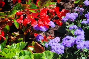 Victoria is the capitol of British Colombia and one of the oldest towns on the west coast. Due to its history, Victoria has a more European feel than many other west-coast cities and is famed for its great weather and flowers. I have visited several times in the summer, when the weather has been glorious and the flowers in full bloom, and so I can fully agree on both counts.
The city centre is close to the waterfront and quite compact, making it easy to visit on foot. We spent some time exploring the city and waterfront area then visited Beacon Hill Park. This is a lovely park, also next to the sea, and has a number of nice paths as well as great views over the ocean, there was a petting zoo in the heart of the park which the children really loved so has a nice mix of activities. Victoria is surrounded by ocean on three sides and we have been to several beaches on our visits, in the city they are busy and have parks and ice cream shops but only a short distance from the main city they become much quieter so there are options for everyone. We also explored some of Dean Park, a larger wooded area to Victoria's north, all of which also feels a long way from a busy city with dense woodlands and wandering paths.
North of Victoria is the small town of Duncan. This is on the main road so makes for a good break point. Here we tried some native Canadian cuisine as well as seeing the largest hockey stick in the world, hence worth a note in passing.
Nanaimo and Surroundings
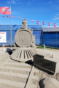
Further up the coast from Victoria is the sea-side town of Nanaimo. With amazing view over the Salish Sea to the mountains on the mainland Nanaimo is also a really nice place. We had a few days in the area and visited Parksville, another seaside town that is famed for its sandcastle completion. We were lucky to visit during competition month and the sandcastles are very impressive. This started as people making sandcastles on the beach and has grown into a professional affair, it is hard to believe some of the structures on display are made from sand. Just inland we also visited the town of Coombs. This is quite rustic and is known for its hippy feel. We visited for lunch and the food was excellent and all the nicer for siting out in the lovely Canadian sunshine.
Ucluelet
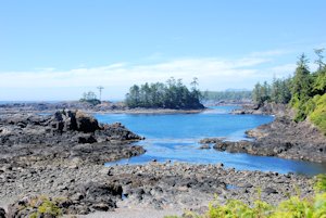 Ucluelet is on the West side of Victoria island and just down the coast from the more famous Tofino. Ucluelet is on the shore of the Pacific Ocean, and so is a base for many activities, the most famous being whale watching. When we arrived, we tried all the whale watching companies but all were fully booked for the week. We had been told it was sometimes possible to see whales just off the coast if you hiked out to the headland. We visited twice but were not lucky enough to see any whales. Ucluelet has some nice places to eat, but not a great deal else. Our visit was for a few days so on the last day we drove up the coast to see some of the bigger beaches that cover much of the coast in this area. These are really long and sandy with big rolling pacific ocean waves so recommended if you like peaceful beach holidays or surfing.
Vancouver
 We have passed through Vancouver several few times on different visits; the city centre is nice and the quality of food is excellent. I really enjoyed the China town area for restaurants, but there are many others. The greatest attraction of Vancouver is Stanley Park. This is situated on a small island in the mouth of the port. It is a nice day out with lots to explore; on one trip we hired bikes and cycled around the edge of the island which I can highly recommend as there is plenty to see and the going is very easy.
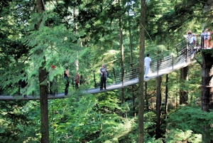
Vancouver is split by rivers, with the city centre in the south. The northern suburbs are more residential but then open into the mountains as you travel further from the city. Still inside the norther part of the city is the Capilano Suspension Bridge, on one trip we had opted to stay in the north to be on the fast road out of the city the following day, so we gave this a visit. Whilst quite expensive the Capilano Suspension Bridge is a nice afternoon out, the bridge is the main attraction, spanning the gorge high above the river, but there are also many small forest walkways and trails to look around.
Penticton
 Penticton is home to one of Jana's brothers and so we have visited a number of times. It sits between the Okanagan Lake to the north and Skaha Lake to the south and, with mountains not far away too, is again a great base for outdoor activities and water sports. On our first visit we hired inner-tubes and spent a relaxed afternoon drifting down a river. On our second trip we headed to one of the lakes and I tried paddle boarding for the first time, this was very enjoyable, and quite easy going when the water was perfectly calm but quickly got more difficult when there was the tiniest amount of swell.
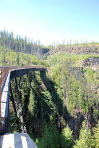
On one trip, on our way from Penticton to Vancouver we took a detour to visit Myra Canyon. This is part of the old Kettle Valley Railway which was built to transport silver for the Kettle Valley to Vancouver. The route was very challenging to build and at Myra over a 12 km stretch there are 18 wooden trestle bridges and 2 tunnels. The railway only operated from 1915 to 1961 but at Myra the trestles have been restored and the route converted to a cycle way. Even getting to Myra is something of a challenge with the last few kilometres on unpaved roads, but the remoteness is part of the real joy of the experience and the cycle ride was really great. Again, the sky was blue and the view over the mountain range impressive.
Still following the Kettle Valley Railway, we also visited the Othello Tunnels. These are a series of 5 tunnels and two bridges that were needed to navigate the Coquihalla River, which at Othello had cut a 300-foot-deep gorge in solid granite. Again, there was a nice walk that follows the old railway line, through the tunnels and then into the wooded valley. Whilst only a brief stop this is again a good break point when travelling from Vancouver.
Salmon Arm
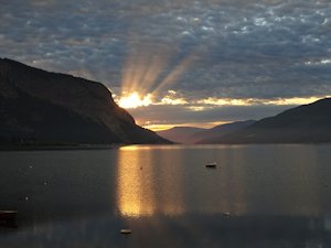 Salmon Arm is a small town situated between the Coastal and Rocky Mountains on the shores of the Shuswap lake. In summer there is lots of sun and in winter there is usually heavy snowfall, and with hill and lakes all around there is a great range of outdoor activities. Jana's grew up here and her parents own a cabin on the edge of the Lake which has made a good base for our trips.
When I visited in winter, I tied a little cross-country skiing in the local woods, this was harder than I expected but after half an hour I had stated to get the hang of it a little. We also went snow shoeing a couple of times, first out at the edge of the lake, and then to see a frozen waterfall at Margret falls. While the waterfall was not yet fully frozen the path was pure ice making me grateful for the snow shoes and as the sun set it made the whole place very beautiful in the half light. We visited Margret falls again in the summer but this time motored across the lake then walked up the trail. This time the weather was lovely and we even braved the still-freezing water to climb up into the small cave hidden behind the falls.
In the summer we also got to borrow a kayak and went with Jana's dad to explore the small secluded Gardom lake, this was very nice and had many small turtles sunning themselves on logs. Water sports are popular theme and we also had time to canoe and paddle board on the lake as well as do a little sailing.
Rockies
We visited and Rocky Mountains both in summer and winter and both are amazing for different reasons.
Summer
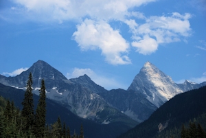 We started our summer trip out from Salmon Arm on our 2015 trip. We drove up into the mountains and then started our sightseeing at the Spiral Tunnels look out. From here it is possible to see the immense trains that carry the coal from the mines around Calgary down to the ports of Vancouver. The trains are so long, and the mountains so steep, that it is possible to see a single train at three separate locations on the mountain as they spiral through a range of tunnels and cuttings. Whilst neat to see, the Rockies are more famed for their scenery and our next stop was very much more impressive: the Takakkaw Falls. Nearly 400m high, this spectacular waterfall is a highlight of the Yoho national park. We spent the morning walking around the base of the falls and up to the lower levels. After this we travelled over to Emerald Lake with a brief lunch detour to see a Natural Bridge spanning the kicking horse river. This is also impressive with the water forced to travel through an outcrop of particularly hard rock.
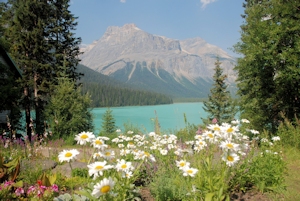 We spent the afternoon walking around Emerald Lake. The sun was bright and the lake gleamed with an emerald green colour. The walk passes around the exposed western side of the lake where the trees are thin and the ground hard, and then through the northern alluvial fan where there is a small wild flower meadow. The walk then continues to the eastern side where the mountains form natural protection and the ground is wet and boggy, creating an ideal wetland habitat. This is hence a really varied and nice walk and at all times you can see the stunning green of the lake itself. We finished the walk with a drink in the lodge and then headed back to Wapta Lake where we were staying. In summer accommodation is limited as this area is very popular. We had left it quite late and as far we the websites showed there are only 2 bunks left in a dorm in the whole area. We were hence lucky to get a place to stay and highlights that it is well worth booking ahead in peak season.
After dinner I had an evening walk from the Lodge. I was aiming for Sherbrooke Lake, which is some way off the main tourist trails, and looked nice on the map. The sun was setting and the going slow and so, with the increasing feeling that a bear encounters might be possible in the isolated forested hillsides, I turned around half way and headed for back. This was still a nice walk and great to see the sun slowly set over the mountains.
 The following day we headed over to the Lake Louise ski resort. In summer one of the gondolas still runs and provides a serene ride up into the higher mountains. It is said that Grizzly bears can be seen from the safety of the gondolas, but we did not see any. However, the views from the top were great and wild flowers covering the mountains were amazing. We spent some time having a walk around the mountain, then headed back down for lunch.
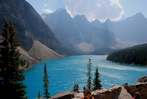
In the afternoon we travelled on to Moraine Lake, this is a spectacular bright blue glacial lake to the south of Lake Louise. It was very busy here, and for a good reason, as it is a really beautiful lake. We had a walk around the lake and climbed over the impressive moraine from which the lake gets its name. Our aim was to walk over to Consolation Lake, few kilometres further on, but at the trail head there was a sign warning of bears and saying a minimum of four people should be present in each walking group. Luckily, we met another couple from London who also wanted to do the walk, and so hiked over to Consolation Lake together. This was a much quieter area and really pleasant. The water is less vibrant in colour but the lake is surrounded by mountains and with great views all around it makes for an enjoyable excursion. After a drink and cool down we pressed on to see the sun set over Lake Louise before heading on to Banff. Here we had an amazing meal of cheese fondue and selections of Canadian meats before retiring for the night.
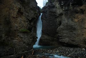
The following day was our last and we drove over to Johnston canyon. This is a great walk following a river that has carved a narrow canyon out of the rocks. The path starts in a wooded area and then quickly joins the river. Due to the steepness of the rock wall the path clings to the cliff edge and is often made up of metal walkways bolted to the sides. The path first makes its way to the lower falls that are viewed through a short cave. The water is tightly constrained here and thunders into a swirling pool at the base of the waterfall and is really very impressive. From the lower falls the path heads up the cliff side and becomes easier going through the woods above the canyon until it reaches the upper falls. These are larger and more open but still well worth the walk.
Winter
 Over the Christmas holidays of 2012 we also had a few days visiting the Rockies, the temperatures were between -10 and -20 and with icy roads we did things more slowly than in the summer. On the first day we travelled out to the town of Golden. Along the way we stopped at Revelstoke, this is a major intersection for the Canadian coal trains, and has a train museum which is nicely done although we did not spend long in the outside areas. We also saw the last spike, where the Canadian west and east coasts rail lines were finally connected, this was all under deep snow so there was not so much to see but has historic significance as the West coast of Canada was quite isolated before the connection of the railways.
The town of Golden is nestled in the mountains has spectacular views in all directions. The guest house was nice and in the morning of our first full day we had quick walk out to a lovely wooden footbridge over the river.
 The river was frozen solid and the air was full of ice crystals, making the morning sun feel very bright and fresh, and giving me my first real experience of how cold the weather was going to be for the trip.
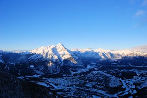
From Golden we headed further into the mountains, with the scenery becoming more breath-taking at every turn. After a quick lunch stop at Lake Louise, we made it to Banff mid-afternoon. We headed for Sulphur Mountain, where it is possible to get a cable car to the top of the peak. This opens out a full 360-degree panorama of the mountains. From the cable car station, it is a short walk over the adjacent peak, but with strong winds and freezing temperatures it is slightly more exhilarating than might be expected. However, the walk over is worth it as the views are even better. The sun started to dip below the mountains as I was there, providing beautiful sunset shots with the sky turning pink and touching the snow-capped peaks with orange light. After coming back down we headed to the hot spring at the base of the mountain to warm up. While incredibly busy, the water was lovely and warm and was a fitting end to the day.
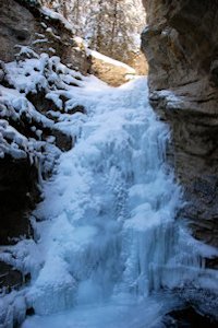
From Banff we headed out to Johnson Canyon. Here the temperature was around minus 20 degrees so we had to wrap up warm. The walk out along the boarded sections above the frozen river were challenging but worth it to see the large waterfall, that in summer had been thundering through the gorge and was now frozen solid among the rocks.
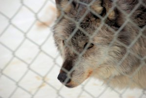 Heading out from the canyon we met with a group of mountain goats, but disappointingly no moose, and continued back to Lake Louise. Not surprisingly Lake Louise is frozen over in the winter too, and so I tried ice skating on the lake as the sun went down and then we had a walk out over the frozen water again in the morning. That afternoon we visited the Northern Lights wolf sanctuary where they have a number of wolves who are looked after by the owners. It is possible to go out with the wolves but only at a considerable cost, and so we contented ourselves with the tour before heading back to Salmon Arm and the chance to fully warm up.